Isaias downgraded to tropical storm over eastern N. Carolina


NORTH MYRTLE BEACH, S.C. (AP) — Hurricane Isaias has been downgraded down to a tropical storm after making landfall near Ocean Isle Beach, North Carolina, according to an official with the National Hurricane Center.
The hurricane had touched down just after 11 p.m. on Monday with maximum sustained winds of 85 mph (136 km/h). The storm now has maximum sustained winds of 70 miles per hour (117 km/h).
“Now that the center has moved further inland into east North Carolina, the winds are now coming back down, so it has been downgraded back to a tropical storm,” Robbie Berg, a hurricane specialist with the National Hurricane Center, told The Associated Press.
The weather service also said in its 4 a.m. advisory that threats of tornadoes were beginning to spread into southeastern Virginia.
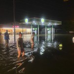
The storm set off flooding and sparked five home fires in Ocean Isle Beach, Debbie Smith, the town’s Mayor, told WECT-TV. Firefighters from the town’s fire department were battling the blaze with assistance from Horry County firefighters in South Carolina, Tony Casey, a spokesperson for Horry County Fire Rescue, told The Associated Press.
About 80 miles (128 kilometers) north of Ocean Isle Beach, about 30 people were displaced due to a fire at a condominium complex in Surf City, news outlets reported. It is not clear if the fires were connected to the storm. No injuries have been reported.
The storm could continue to bring down trees and cause power outages as it moves north along the mid-Atlantic and New England coastline, Berg said.
“We don’t think there is going to be a whole lot of weakening, we still think there’s going to be very strong and gusty winds that will affect much of the mid-atlantic and the Northeast over the next day or two,” Berg said. Rainfall will continue to be a big issue, he added.
Duke Energy reported hundreds of thousands of power outages as heavy rains and winds battered areas including Wrightsville, Kure, and Carolina beaches in Wilmington, North Carolina.
Coastal shops and restaurants closed early, power began to flicker at oceanfront hotels and even the most adventurous of beachgoers abandoned the sand Monday night as newly restrengthened Hurricane Isaias sped toward the Carolinas.
The U.S. National Hurricane Center warned oceanside home dwellers to brace for storm surge up to 5 feet (1.5 meters) and up to 8 inches (20 centimeters) of rain in spots, as Isaias moved up the coast. The Carolinas weren’t the only states at risk.
“All those rains could produce flash flooding across portions of the eastern Carolinas and mid-Atlantic, and even in the northeast U.S.,” said Daniel Brown, senior hurricane specialist at the U.S. National Hurricane Center. A tropical storm warning extended all the way up to Maine, where flash flooding was possible in some areas on Wednesday.
The center also warned of possible tornadoes in North Carolina early Tuesday, and from eastern Virginia to southern New England later Tuesday.
Isaias (pronounced ees-ah-EE-ahs) was upgraded again from a tropical storm to a Category 1 hurricane Monday evening. Early Tuesday the storm, downgraded again, was centered about 25 miles (40 kilometers) northwest of Greenville, North Carolina. It was moving quickly north northeast over eastern North Carolina at 26 mph (41 kph) and this general motion accompanied by an increase in forward speed is expected through Tuesday.
The center will move into southeastern Virginia around daybreak, near or along the coast of mid-Atlantic states and continue across the northeastern United States later into the evening. Strong winds and heavy rainfall were expected to spread northward along the mid-Atlantic coast Tuesday morning.
The storm’s maximum sustained winds dropped from when it hit land to 75 mph with higher gusts but only a gradual weakening is anticipated.
Hurricane-force winds extended outward up to 25 miles (40 km) from the center, and tropical-storm-force winds extend outward up to 125 miles (201 km). A wind gust to 64 mph (102 km/h) was recently reported near Bogue, North Carolina.
Isaias killed two people in the Caribbean and roughed up the Bahamas but remained at sea as it brushed past Florida over the weekend, providing some welcome relief to emergency managers who had to accommodate mask-wearing evacuees in storm shelters.
Authorities in Myrtle Beach, South Carolina, ordered swimmers out of the water to avoid rough surf and strong rip currents. By nightfall, power began to flicker at beachfront hotels as Isaias crossed the last bit of warm water on its path toward the U.S. mainland.
Still, on this part of the South Carolina and North Carolina coasts that has been affected to varying degrees by seven tropical storms or hurricanes since 2014, residents weren’t panicking.